Applying the latest science to provide you with mapping, modeling, assessment, and development of best practices
By synthesizing and effectively communicating data and a vast body of knowledge, NatureConnect helps develop a wide variety of foundational resources to inform action by conservation practitioners, policymakers, and the public. Our Planning and Assessment services help partners identify threats to landscapes, prioritize the most important and feasible areas to conserve or restore ecological connectivity, and use the most effective and efficient strategies for conservation.
Connectivity Modeling, Mapping, and Prioritization
By using data about species movement, environmental factors, and human impacts as inputs, we use a variety of approaches and algorithms to spatially model connectivity areas that best allow species to move across landscapes, including between protected areas and intact and fragmented habitats. The resulting maps are decision-support tools that can inform partners about where and how to maintain, enhance, and restore connectivity at larger scales. Examples include:
- Provided visualization and evaluation of scenarios for restoring connectivity for Climate-Smart Cocoa Landscapes in Ghana.
- Developed an innovative habitat connectivity model for the Custer-Gallatin National Forest’s Forest Plan in Montana
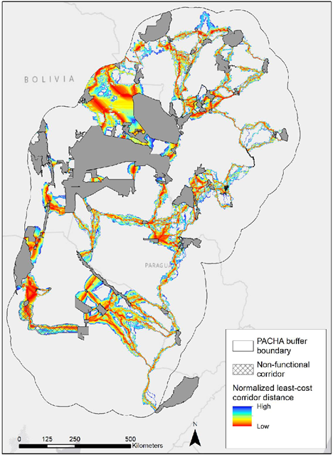
- Conducted a connectivity analysis for the Pantanal-Chaco region of South America to identify the most important corridors for jaguar movement
Assessments & Recommendations
Assessing and Advancing Connectivity Policy
The Center—often in partnership with other organizations and as part of broader coalitions—informs, writes, analyzes, and advocates for stronger connectivity policies, plans, and funding at the local, state, national, and international level. Examples include:
- Worked with partners to craft and advance the first-ever federal Wildlife Crossings Pilot Program and developed a toolkit for grant applicants to plan effective projects under that program.
- Provided policy analyses of the state of New Jersey to identify existing connectivity policy barriers and opportunities
Assessing and Advancing Governance and Best Management Practices
The Center can help partners evaluate sociopolitical challenges and opportunities for connectivity conservation. We can also facilitate a process to identify recommended management practices, especially within ecological networks and corridors. Examples include:
- Worked with the Quebec Ecological Corridors Initiative, hosted by the Nature Conservancy of Canada, to advise on corridor design, governance, and management and monitoring plans through partner workshops and capacity-building trainings with conservation practitioners.
- Modeled the most critical ecological corridors in the Pantanal-Chaco region of South America (see above), then coordinated a workshop with partners during which experts decided on a set of criteria for which each of the modeled corridors will be scored. The result is a map with the five to eight priority corridors to conserve in each country—Bolivia, Argentina, Brazil, and Paraguay.
Linear Infrastructure Assessments to Identify Threats to Wildlife Movement
The Center has a depth of experience and expertise to assist government agencies in the U.S. and abroad assess and mitigate threats to habitat connectivity from roads, rails, and transmission lines. This includes mapping and evaluating priority locations for wildlife crossings and other mitigation measures, developing capacity-building training modules, and advising on the technical design and location of wildlife-friendly infrastructure. Examples include:
- Analyzed linear infrastructure threats to biodiversity in Asia for the USAID-funded LISA Project. We developed a Composite Biodiversity Index (CBI) and overlaid it with spatial layers of existing and planned linear infrastructure in the region.
- Performed coarse-scale analyses of highways in 11 U.S. states to provide valuable information to state Departments of Transportation through the West-Wide Study to Identify Important Highway Locations for Wildlife Crossings.
- Developed, with our partner the Western Transportation Institute, replicable methods for identifying priority sites for wildlife crossings and other safe-passage measures, assessing feasibility, and developing recommendations for implementation. We successfully used this approach for the US-191/Montana-64 Wildlife & Transportation Assessment and for Yellowstone Safe Passages.
Photos top to bottom: Himalayan Mountains – Adobe Stock; Mapped jaguar movement corridors connecting protected and conserved areas and Indigenous territories in the Pantanal-Chaco landscape of South America – CLLC; Young bighorn sheep on a road – Adobe Stock.