Development and deployment of tools to measure and monitor progress toward your connectivity goals
Tracking progress toward connectivity conservation objectives is essential. Monitoring promotes opportunities to learn from each project, adapt management to fit changing conditions, and refine best practices to apply in the future. On a larger scale, it is critical to understand our collective progress toward national and international goals for connectivity conservation. Through NatureConnect, the Center not only deploys but also develops new tools for monitoring and evaluating the effectiveness of connectivity conservation activities.
Monitoring Functional Connectivity
 In connectivity conservation, it is particularly important to monitor functionality, or whether ecological processes are occurring and how well genes and wildlife are moving through landscapes. Landscapes that are structurally connected—such as by corridors—do not necessarily guarantee that natural functions such as gene flow or pollination are maintained, enhanced, or restored. Monitoring the ecological function of corridors can focus on achieving either the ultimate desired ecological outcomes or on reducing negative impacts such as the level of fragmentation, disturbance, or degradation. NatureConnect provides support with preparing and writing corridor management and monitoring plans, identifying specific and achievable indicators to measure changes over time, advising on data collection and monitoring, and analyses to inform management actions. Examples include:
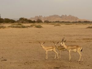
- Wrote corridor management and monitoring plans for creating a network of protected areas in AlUla, Saudi Arabia, that provides habitat for desert-adapted species such as gazelles, ibex, vultures, and even—in the future—the re-introduced Arabian leopard.
Development and Deployment of Connectivity Metrics, Databases, and Applications

The Center plays a central role in developing tools that evaluate ecological connectivity and monitor progress toward related goals. For example, we co-developed the Protected Network Metric (ProNet) with science advisor Dr. David Theobald as an advanced tool for tracking annual progress toward implementation of ecological connectivity. Additionally, we advise on creation of the World Database on Ecological Corridors in partnership with the UN Environment Programme’s World Conservation Monitoring Centre (WCMC). We can apply these monitoring tools and/or train professional teams, government agencies and community members to use them. Examples include:
- Deployed ROaDS—a mobile web tool that can be used by agencies or citizen scientists to gather data on wildlife-vehicle collisions and wildlife movement near roads through a standardized methodology—for several highway locations, including US Highways 191 and 89 in the Greater Yellowstone Ecosystem and on roads throughout Vermont.
- Tested the ProNet tool to score corridors based on known values, threats, and opportunities, which will be used as part of the Wildlife Connect Initiative.
Photos, top to bottom: Herd of deer – Adobe Stock; Sand gazelles (Gazella marica) in Saudi Arabia – CLLC photo; Black bear crossing a road, Alberta, Canada – Adobe Stock.